
Changes to county-equivalents for Connecticut
Connecticut’s eight counties ceased administrative functioning in 1960. In place of the former counties, Connecticut has nine planning regions that act comparably to counties in other states. Connecticut’s planning regions do not map directly to the former counties.
In 2019, the Connecticut Office of Planning and Management petitioned the U.S. Census Bureau to adopt the nine planning regions for the purposes of federal data collection and reporting. The Census Bureau made this change internally in 2022 and shifted all Census Bureau products to organize data according to the nine planning regions by 2024.
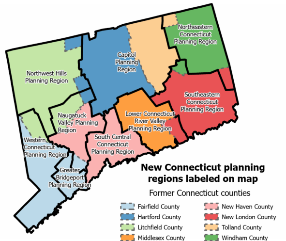
County Health Rankings & Roadmaps has provided data for Connecticut’s eight counties since the first CHR&R national data release in 2011. Beginning with the 2025 CHR&R Data Release, new County Health Snapshots will be available both for Connecticut’s nine planning regions and eight counties. New snapshots will be labeled with planning region names and will share all data available for the planning regions. CHR&R data come from many different sources with varied practices used to collect and summarize data. Some of our data sources have not yet adopted the Connecticut planning regions and measures using these data sources will continue to be updated in the snapshots representing Connecticut's eight former counties. Measures available for the planning regions will not be available for the eight former counties and eventually the snapshots for the former counties will no longer be updated.
County Health Snapshot names and available measures for Connecticut (CHR&R 2025)
Planning Regions
| Name | FIPS CODE |
|---|---|
Capitol | 09110 |
Naugatuck Valley | 09140 |
Northeastern Connecticut | 09150 |
Northwest Hills | 09160 |
South Central Connecticut | 09170 |
Western Connecticut | 09190 |
Southeastern Connecticut | 09180 |
Greater Bridgeport | 09120 |
Lower Connecticut River Valley | 09130 |
CHR&R measures available for planning regions in 2025 Data Release:
Poor or Fair Health; Uninsured Adults; Adult Smoking; Adult Obesity; Homicides; Children in Poverty; Poor Physical Health Days; Motor Vehicle Crash Deaths; Poor Mental Health Days; Income Inequality; Excessive Drinking; Population; % Below 18 Years of Age; % 65 and Older; % Non-Hispanic Black; % American Indian or Alaska Native; % Hispanic; % Female; % Rural; % Not Proficient in English; HIV Prevalence; Median Household Income; Children Eligible for Free or Reduced Price Lunch; Driving Alone to Work; Some College; Physical Inactivity; % Native Hawaiian or Other Pacific Islander; % Asian; Children in Single-Parent Households; Uninsured; Uninsured Children; Drinking Water Violations; % Non-Hispanic White; Child Mortality; Long Commute - Driving Alone; Drug Overdose Deaths; Food Insecurity; Social Associations; Residential Segregation - Black/White; Insufficient Sleep; Frequent Physical Distress; Frequent Mental Distress; Firearm Fatalities; Disconnected Youth; Gender Pay Gap; Severe Housing Cost Burden; Broadband Access; High School Completion; Access to Parks; % Disability: Functional Limitations; Feelings of Loneliness; Lack of Social and Emotional Support
Former Counties
| Name | FIPS CODE |
|---|---|
Fairfield | 09001 |
Hartford | 09003 |
Litchfield | 09005 |
Middlesex | 09007 |
New Haven | 09009 |
New London | 09011 |
Tolland | 09013 |
Windham | 09015 |
CHR&R measures available for former counties in 2025 Data Release:
Premature Death; Preventable Hospital Stays; Teen Births; High School Graduation; Unemployment; Low Birthweight; Mammography Screening; Air Pollution - Particulate Matter; Premature Age-Adjusted Mortality; Infant Mortality; Injury Deaths; Life Expectancy; Flu Vaccinations; Reading Scores; Math Scores; Suicides